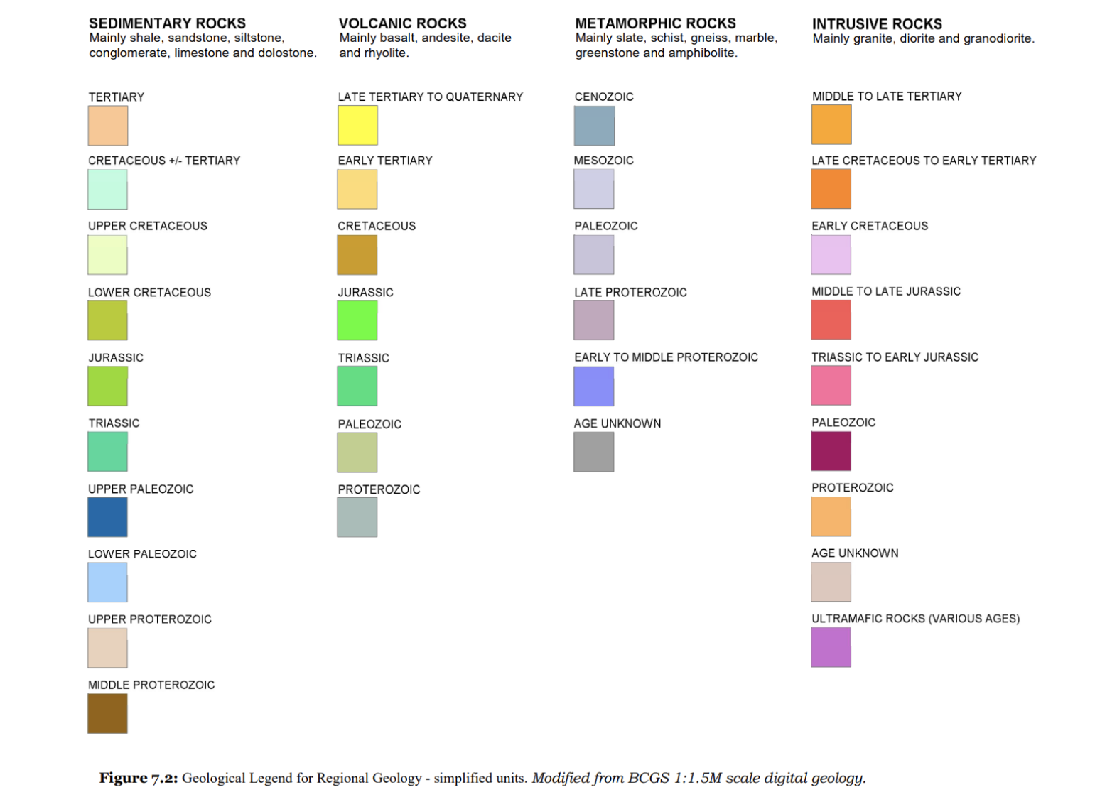
.png)
ON THIS PAGE
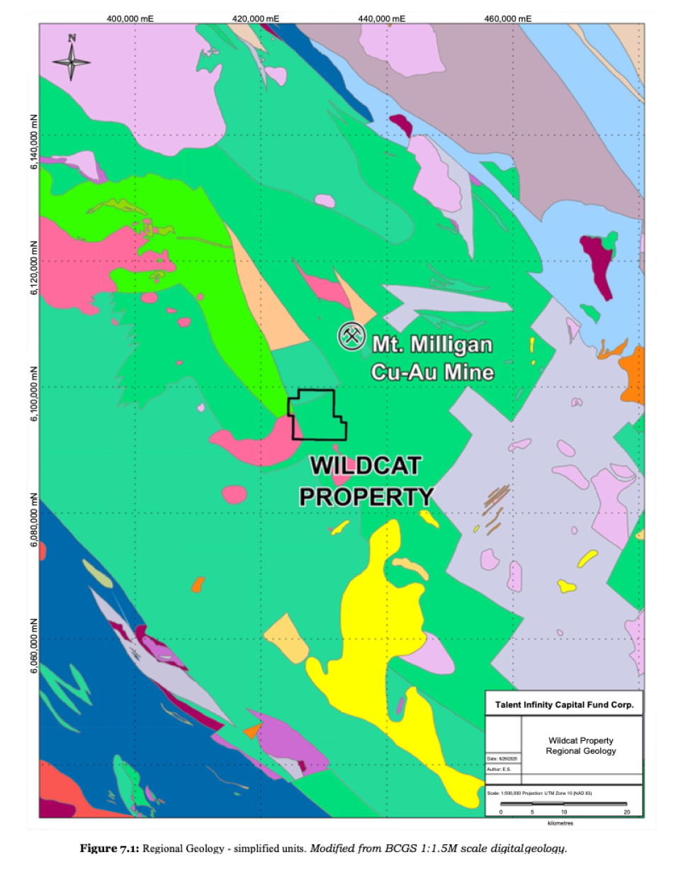
Regional Geology
Local and property geologyGeogical Settings & Mineralization
Regional Geology
The Mount Milligan Copper-Gold Mine is operated by Centerra Gold Inc. and is located approximately 10 kilometres to the northeast of the Wildcat Property. Production of copper-gold concentrate commenced in September 2013, followed by the first truckload of concentrate to Mackenzie on September 24, 2013. Accumulated copper-gold concentrate is shipped via rail to the port of Vancouver. The Mt. Milligan Mine is a conventional truck and shovel open-pit mine designed to process 60,000 tonnes per day of copper-gold bearing ore. The recently revised planned mine life is 9 years with a Proven and Probable Reserve of 191.0 million tonnes @ 0.23% copper and 0.39 g/t gold (Fitzgerald et al., 2020).
The Quesnel Terrane formed along or near the western North American continental margin and accreted to the margin in the late Early Jurassic (186-181 Ma). Quesnellia is found along most of the length of the Canadian Cordillera and in the Nation Lakes area is characterized by Late Triassic to Early Jurassic volcanic and sedimentary rocks of island arc affinity (Nelson and Colpron, 2007)..
The Quesnel Terrane is in contact to the east with Proterozoic and Paleozoic carbonate and siliciclastic rocks of the Cassiar Terrane, representing part of the ancestral North American miogeocline. In places, the Quesnel and Cassiar terranes are separated by an intervening assemblage of late Paleozoic oceanic rocks of the Slide Mountain Terrane. The boundary between the Quesnel and Cassiar terranes is a complex structural zone that includes late Early Jurassic east-directed thrust faults that juxtapose the Quesnel Terrane above the Cassiar Terrane.
Towards the west the Quesnel Terrane is in fault contact with the late Paleozoic through mid-Mesozoic oceanic rocks of the Cache Creek Terrane, interpreted to be part of the accretion-subduction complex that was responsible for generating the Quesnel Magmatic arc. Younger rocks commonly found in the region include Cretaceous granitic stocks and batholiths, Eocene volcanic and sedimentary rocks, and flat lying basalts of both Neogene and Quaternary age.
Intrusive units of a wide variety of sizes, ages, compositions and textures occur in the region. The largest bodies are the Hogem and Germansen batholiths. The Hogem Intrusive Suite is composed of many discrete plutons including mafic to syenitic Late Triassic to Early Jurassic intrusions, as well as mid-Cretaceous granites. A myriad of small intrusions and some larger ones are equivalent to the Early Jurassic volcanic units and to the late stages of Takla Group volcanism. Significant porphyry copper-gold deposits in the area are associated with “crowded porphyries”. In a typical crowded porphyritic monzonite, small blocky plagioclase phenocrysts (1-2 mm), with lesser hornblende, biotite and/or augite touch each other in a fine-grained matrix of plagioclase, potassium feldspar, mafic and oxide minerals.
In the Mt. Milligan area, the Takla Group is informally subdivided into a lower, predominantly volcaniclastic Inzana Lake Succession and an upper, predominantly pyroclastic Witch Lake Succession. The Witch Lake Succession, the host of the Mt. Milligan deposits, is characterized by augite-phyric pyroclastic rocks and coherent basalt to andesite, subordinate epiclastic beds and co-magmatic Takla Group and post- Takla Group intrusions. Coeval intrusions comprise most of the Mt. Milligan intrusive complex consisting of monzonite with minor diorite and monzodiorite.
The Quesnel arc had two predominant phases of development: Late Triassic and Early Jurassic. The first, Late Triassic early arc development phase is dominated by augite phyric basalt and alkali basalt (shoshonitic) volcanism. Basal sediments of the Slate Creek succession (235-204 Ma) grade upwards into increasingly volcanic and volcaniclastic rocks of the Inzana, Willy George, Plughat Mountain and Witch Lake successions (230-204 Ma), collectively referred to as the Takla Group. A depositional hiatus marks a break in volcanic activity prior to the onset of renewed volcanic activity in the Early Jurassic.
The second phase of arc development began in the early Jurassic and is characteristic of a more mature arc, developed on thicker crust. These early Jurassic volcanic suites were compositionally more heterogeneous and dominated by plagioclase and plagioclase-augite phyric, sub-alkaline to shoshonitic lithologies. The Triassic arc successions are overlain paraconformably by the early Jurassic suites of the Inzana Lake and Witch Lake Successions.
The Property lies near the southeastern extent of the Hogem Batholith. The Hogem batholith differs from other Upper Triassic batholiths in the Quesnel terrane in two significant ways. It is unusually long lived (Late Triassic to Cretaceous) rather than confined to a shorter interval near the Triassic-Jurassic boundary such as the Guichon and Iron Mask Batholiths. It is unusually long lived (Late Triassic to Cretaceous) rather than confined to a shorter interval near the Triassic-Jurassic boundary such as the Guichon and Iron Mask Batholiths.
The Property lies near the southeastern extent of the Hogem Batholith. The Hogem batholith differs from other Upper Triassic batholiths in the Quesnel terrane in two significant ways. It is unusually long lived (Late Triassic to Cretaceous) rather than confined to a shorter interval near the Triassic-Jurassic boundary such as the Guichon and Iron Mask Batholiths. The Guichon and Iron Mask Batholiths are calc-alkaline and alkaline respectively, whereas the Hogem Batholith is composed of four phases which alternate from alkaline to calc-alkaline, with each phase becoming progressively more felsic.
Regional Mineral Occurrences
The Mount Milligan Copper-Gold Mine is operated by Centerra Gold Inc. and is located approximately 10 kilometres to the northeast of the Wildcat Property. Production of copper-gold concentrate commenced in September 2013, followed by the first truckload of concentrate to Mackenzie on September 24, 2013. Accumulated copper-gold concentrate is shipped via rail to the port of Vancouver. The Mt. Milligan Mine is a conventional truck and shovel open-pit mine designed to process 60,000 tonnes per day of copper-gold bearing ore. The recently revised planned mine life is 9 years with a Proven and Probable Reserve of 191.0 million tonnes @ 0.23% copper and 0.39 g/t gold (Fitzgerald et al., 2020).
The Mt. Milligan deposits are centered on two principal intrusive bodies, the MBX and Southern Star stocks. Within the stocks, monzonite varies texturally and compositionally.
Late syn-mineral plagioclase hornblende porphyritic monzonite dykes are common throughout the Southern Star stock. Hydrothermal breccia occurs extensively throughout the Southern Star stock, and less commonly in adjacent volcanic rocks and along the margins of the MBX stock. It is characterized by potassium feldspar veinlets and flooding that vary in amount and size.
Important east-northeasterly trending cross-faults and northwesterly trending, steeply easterly dipping faults separate the MBX stock from the Southern Star stock.
In the Mt. Milligan area, the Quesnel Terrane is characterized by widespread Late Triassic to Early Jurassic arc rocks comprising (Herbert et al., 2007): Volcanic rocks: mainly volcaniclastics, with subordinate coherent volcanics of basaltic to dacitic compositions. Augite-porphyry is particularly characteristic of Quesnellia, and forms the eastern facies of alkaline to sub-alkaline augite-phyric basaltic andesite; • Coeval and partly comagmatic plutons ranging from calcalkaline (in the west) to alkaline (in the east); and Sedimentary rocks including shale, limestone, and epiclastic deposits.
The Witch Lake Succession hosts the Mt. Milligan deposit, which is characterized by augite-phyric pyroclastic and coherent basaltic andesites, with subordinate epiclastic beds. The Witch Lake Succession is intruded by coeval Takla Group and post-Takla Group intrusions. Coeval intrusions comprise most of the Mt. Milligan intrusive complex, which consists dominantly of monzonitic rocks with minor dioritic/monzodioritic and gabbroic/monzogabbroic rocks.

The Kwanika Copper-Gold Deposit is located approximately 80 kilometers to the northwest of the Wildcat Property and is owned and operated by Serengeti Resources Inc. (“Serengeti”). Discovered in 2006, the Kwanika deposit consists of two closely spaced deposits (Kwanika Central Zone & Kwanika South Zone) containing Indicated Resources of 0.94 billion pounds of copper and 1.42 million ounces of gold at a Cut-off of 0.2% CuEq at the Kwanika Central Zone (Serengeti Resources Inc., 2016).
Copper-gold mineralization in the “Central Zone” consists of disseminated chalcopyrite, bornite and pyrite in and around a potassically altered monzonite stock intruding andesitic rocks of the Takla Volcanic Group. Where strongly mineralized, the unit commonly displays quartz stockwork and hydrothermal brecciation. Copper-gold-molybdenum-silver mineralization in the “South Zone” consists primarily of chalcopyrite and molybdenite with trace amounts of chalcocite, bornite and enargite and is associated with potassically altered alkalic to intermediate composition intrusive rocks (Serengeti Resources Inc., 2016).
n April of 2016, Serengeti announced that it had signed a deal with Daewoo Minerals Canada Corp. (“DMC”), a 100% owned Canadian subsidiary of Posco Deawoo Corp, whereby Posco Deawoo has the right to earn up to a 35% interest in Serengeti’s Kwanika copper-gold project by providing funding of $ 8.2 million.
The BP Chuchi Deposit or Chuchi Lake Deposit is located roughly 25 km to the west-northwest of the Wildcat Property, and is currently owned by Centerra Gold Inc. The BP Chuchi deposit is considered a small, copper-gold alkalic porphyry deposit. Copper-gold mineralization is associated with locally pervasive potassic and propylitic alteration and abundant secondary magnetite and is centered about a cluster of plagioclase porphyry stocks, dikes and sills which intrude a sedimentary unit of the Lower Jurassic Chuchi Lake succession. This sedimentary unit consists of well-bedded sandstones, siltstones and tuffs that grade downwards into massive coarse lapilli tuffs and agglomerates. The best grades fall within a northeast-trending zone that crosses the monzonite stock. A rough estimate (non 43-101 compliant) of the geological resource is 50 million tonnes with grades between 0.21% and 0.40% copper and 0.21 g/t and 0.44 g/t gold (Nelson and Bellefontaine, 1996).
Local and Property Geology
There has been no systematic geological mapping of the Wildcat property other than the 1:50,000 scale regional mapping by (Nelson et al., 1992).
The Wildcat Property has very sparse outcrop with much of the Property covered by till and glaciofluvial gravels (1 to >10 m thick). Reconnaissance prospecting has been conducted by (Day, 1996) and prospecting and geological mapping in the central region by R. Wells (Wells, 2005) and D. Duba (Lustig and Duba, 2008). Recent clear-cut logging activity has opened up new road-cuts and exposed more bedrock in some parts of the Wildcat Property.
Historical diamond drilling has encountered the following Takla Group lithologies; augite-phyric andesite to medium grained gabbro (ANDS), augite-phyric andesite tuff to crystal lithic tuff (ANTF), plagioclase monzonite porphyry (MZPP), hornblende (biotite) ± plagioclase monzonite/diorite porphyry (HMZP) and xenolithic monzonite/diorite porphyry (XNMZ) (Lustig and Duba, 2008).
Augite-phyric andesite to medium grained gabbro (ANDS): The rock is medium to dark green and less commonly pistachio green and dark grey-black with mottled alteration patches (chlorite-epidote), massive, fine grained andesite to intrusive-like medium grained gabbro, the latter probably representing deeper levels of a volcanic pile. Andesite is typically porphyritic consisting of subhedral to euhedral augite, 1-3 mm on average, locally to 5 mm, (<5% to 20%) and locally hornblende laths, <2mm, (0% to 50%), often euhedral and variably chloritized and epidotized, and pale grey subhedral plagioclase, 1-2 mm, on average (0% to 40%) set in an aphanitic to fine grained variably propylitized mafic groundmass. Fragment-supported volcanic breccia zones are rare. These consist of <1 cm to >5 cm subangular andesite fragments in a matrix of similar composition, andesite to fine-medium grained gabbro
Augite-phyric andesite tuff to crystal tuff (ANTF): This lithological unit is only recognized in drill core (WC07-1 and WC07-3) and appears to be subordinate to coherent andesite/gabbro. It is typically dark grey to grey-green, well bedded (foliated), altered, fine grained and contains euhedral/subhedral augite crystals, 1-3 mm (up to 25%), in a fine to medium grained, variably propylitized mafic matrix.
All volcanic rocks are weakly to locally strongly magnetic with magnetite contents up to 5% to 12% as coarse blebs, disseminations and lesser, fine grained fracture fillings that have associated ± calcite-epidotepyrite-chalcopyrite. Pyrite is commonly present as fine disseminations, blebs and narrow veinlets, trace to 2%, averaging 1%.
Andesite to gabbro and andesite tuff are occasionally intruded by narrow, < 5 m wide, plagioclase-phyric monzonite to diorite dikes. These are light to medium grey and grey-green and commonly coarse grained, crowded porphyries consisting of euhedral, 1-5 mm on average, plagioclase phenocrysts (up to 40%). The groundmass is aphanitic to fine-grained matrix and consists dominantly of quartz, K-feldspar>plagioclase and subordinate hornblende, epidote, calcite and accessory pyrite disseminations and veinlets, and occasionally magnetite.
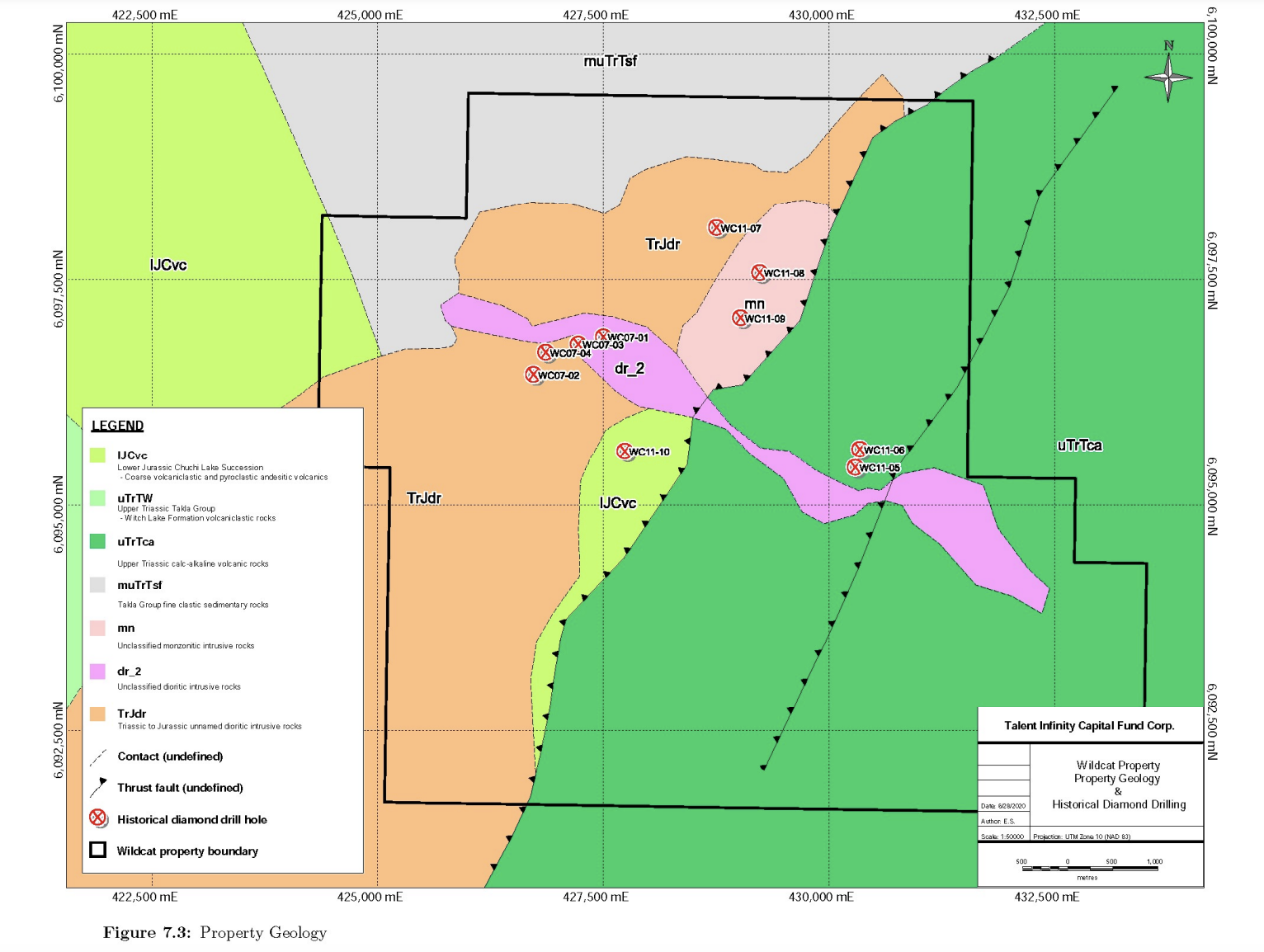
Plagioclase monzonite porphyry (MZPP): The western part of the Property is underlain by small stocks of plagioclase monzonite porphyry (Figure 7.3), the most widespread intrusive rock observed both in outcrop and drill core (WC07-02 and -04). The porphyry is leucocratic, white to light grey, also light green to medium pink, massive to foliated, crowded (up to 50%), megacrystic plagioclase monzonite porphyry featuring euhedral, 2-5 mm, on average, rarely 10-15 mm, plagioclase phenocrysts in an aphanitic to fine grained groundmass of K-feldspar, plagioclase, quartz, minor hornblende and secondary chlorite, biotite, epidote and calcite. Another minor, finer grained phenocryst phase is hornblende (altered to biotite and/or chlorite), 1-3 mm (3% to 5%).
Hornblende ± plagioclase monzonite/diorite porphyry (HMZP): Megacrystic monzonite is intruded by numerous, narrow, (1 to 10 m wide), fine to lesser medium grained, pale beige to medium grey and purple-brown, variably porphyritic hornblende ± plagioclase monzonite to diorite dikes. These contain phenocrysts of dark brown euhedral hornblende (1-5mm, <5-25%,) >wispy biotite and remnant, pale grey subhedral/euhedral plagioclase (1-3 mm, 0 to 35%). Augite phenocrysts (1-3 mm) are extremely rare, <1- 2%. Groundmass is aphanitic to fine grained consisting of a mixture of K-feldspar, plagioclase, quartz and lesser mafic minerals (biotite>chlorite, epidote).
Xenolithic monzonite/diorite porphyry (XNMZ): This lithotype occurs as rare, narrow (<5 m) dikes compositionally similar to plagioclase-hornblende monzonite/diorite. It is composed of <10% poorly sorted, <0.5 cm to >3 cm angular to partially assimilated andesite fragments set in a fine to medium grained plagioclase-hornblende phyric monzonite to diorite groundmass.
Intrusive rocks are generally weakly to lesser moderately potassically altered with weak overprinting propylitization. Potassic alteration is in the form of fine-grained biotite replacement of mafic phenocrysts (minor plagioclase?) and matrix. Propylitization is typically weak and intermittent comprising of chloritecarbonate (calcite)-epidote-albite(?)-pyrite assemblage and is found predominantly as fracture-controlled replacement. Silicification is weak and occurs as narrow (<0.5 to 1cm) veinlets of quartz ± calcite ± pyrite and as rare, pervasive silicification.
Pyrite occurs as fine-grained disseminations, blebs and lesser fracture filling (<0.1 to 2.5%, averaging 1.5%). Associated with pyrite is disseminated and blebby pyrrhotite (trace to 0.5%). Sporadic and limited chalcopyrite mineralization occurs as disseminations, blebs and locally as pyrite-chalcopyrite vein fill, all of which are generally associated with propylitic alteration assemblages.
Several fault-lineaments are apparent on the Wildcat Property. These are interpreted structures trending northwest (monzonite porphyry-volcanic contact) and northeast (Rainbow Creek) with unknown dips. The drill logs indicate a rare brittle deformation along intrusive contacts.
Property Mineralization & Alteration
In part due to the till covered nature of the Property, mineralization encountered to date on the Property is limited to copper mineralization encountered in historical drilling. The most significant copper ± gold± silver mineralization was encountered during the 2011 Cayden Resources drilling campaign. Significant intervals from this program include:
The Mt. Milligan deposits are centered on two principal intrusive bodies, the MBX and Southern Star stocks. Within the stocks, monzonite varies texturally and compositionally.
. DDH # WC11-07, 213.8 m to 214.52 m (0.72 m) @ 1.34% Cu, 0.626 g/t Au, 16.2 g/t Ag: DDH # WC11-08, 155.45 to 181.60 m (26.15 m) @ 0.14% Cu, 0.034 g/t Au, 0.74 g/t Ag; incl. 170.95 m to 181.60 m (10.65 m) @ 0.21% Cu, 0.062 g/t Au, 1.1 g/t Ag
The aforementioned mineralized intercept from WC11-07 was associated with a roughly 0.5 cm quartzpyrite-chalcopyrite shear hosted vein with strong epidote selvages, in what is otherwise propylitically altered diorite. The mineralized interval from WC11-08 consists of chalcopyrite and pyrite blebs and disseminations in a propylitically altered diorite, with sporadic quartz-calcite-pyrite ± chalcopyrite veins and localized strong chlorite alteration. The interval from WC11-08 includes a moderate to strongly sheared and chlorite altered mafic dike than contains significant pyrite and lesser chalcopyrite.